Friday, March 11, 2016

PT. 3784 W6/CT-168

Easy drive from the house up the 210 to N/B 5 fwy, 14 fwy north, exit Sierra Hwy to Escondido Cyn Rd.   I grabbed a cup of coffee and headed out around 6am.  All the traffic was headed S/B towards Los Angeles.  I was listening to an audio book and next thing I knew, I was in Palmdale, missing my turn by about seven miles.  I made a U-turn at Palmdale Bl and headed back.

I thought I would try a different approach from what Dan and Hal took.  I didn't want to deal with anyone talking about trespassing on what should be public property.  I parked just over a mile east from where they entered.  The parking is at  34° 30.033'N 118° 13.919'W.  I followed the lower hills up to the ridge, about .75 miles with an elevation gain of 700".  There is no trail until I reached the ridge.  The last .25 mile to the ridge was steep.  It took me 40 minutes to complete the .75 mile to the ridge and about 5 minutes along the ridge for the last .25 mile to the summit.


The picture doesn't do justice to the last push to the ridge.  I was thinking I should have gone the way of Dan and Hal, talking to the lady about passing their property.  Roxy found some shade to wait for me.  I followed a couple animal trails up to the ridge.  It was warmer than I expected.


Once on the ridge, it is relatively flat to the summit, about .25 mile away.  As I was walking along the ridge, I began thinking the hike to the ridge wasn't too bad.  There is a nice trail that follows the ridge.


I came across the summit quickly.  It was a pile of rocks offering good views in all directions.
I stood on the rocks, looked west and thought that must be the route coming from the other direction.


I pulled out my antenna and noticed that the matchbox was disconnected.  I checked my pack and couldn't find the small pair of pliers I normally bring to make the repair.  Fortunately, I had recently purchased the LNR "Trail Friendly" antenna.  It is small and fit in the palm of my hand.  I 
had wanted to try it, so I guess now was the time.


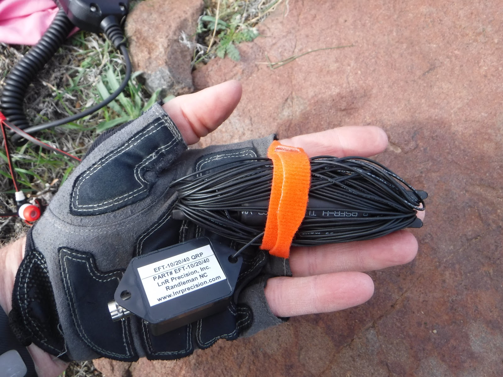
When I went to set up the new antenna, I noticed the hole on the matchbox and the radiator that I normally attach rope for hanging the antenna, was much smaller and my rope would not fit.   I checked my pack for extra rope and surprise, I didn't have that either.  What a day!  I checked around the summit for some string and wouldn't you know it, I was on a summit with no trash.  I looked down, thinking what to do, when I noticed my shoelace.  It worked perfect!


I ran the antenna from north to south.


Roxy got some good rest while we were on the summit during the activation.


Nice views from the summit in all directions.  The first picture is Parker Mtn which I activated a while back.  The temperature suddenly dropped at least ten degrees and the wind started to pick up.  I could see the storm clouds moving in.  


 Always nice to see the truck on the way back down.  When I arrived, I noticed that CHP issued me a warning  for not parking more than 72 hours.  I guess it is time to get a new truck as he probably thought my 97 was abandoned.


 I worked 10, 20, and 40 meter bands today, making contacts all over the country.  A lot of QSB and noise.  Thank you chasers!

10m -  NE4TN, KG3W, N4EX, KI4AAU

20m - N7BHP, W0MNA, W0ERI, N8DEA, KF7JQV, K3JH, KB9AIT, NS7P, N1GB

40m - W7RV, KX6A, AA7DK, K6EL

Saturday, March 5, 2016

Mt. McDill W6/CT-118

I have wanted to activate on Mt McDill for some time, but weather is always a factor.  This summit is susceptible to high winds.  Today was a perfect day.  Temperature was low 60's when I arrived at the parking location and no wind!  Roxy and I stopped at Starbucks in the neighborhood before starting the approximate one hour drive up the 14 fwy.  I exited  and made a left on Palmdale Bl which becomes Elizabeth Lake Rd to Bouquet Cyn Rd. where I turned left.  The parking for McDill is at     N34° 35.198' W118° 18.322'.  The hike to the summit is nearly 3.5 miles with a 1500' elevation gain.

 
After parking, follow the Edison road to the gate.  When parking, the sign on the gate warns to not block the gate.  Walk past the gate and follow the road.

 
At N34° 35.139' W118° 18.191' you come to the first fork.  Follow the road to the left.


The dirt road is in very good condition and offers some nice views of the surrounding, rolling hills. At  N34° 34.845' W118° 17.736' it is time to leave the road and follow the trail to your right.


The trail is in good shape and offers some nice views.


At N34° 34.330' W118° 17.174' the trail rejoins the road.  Turn to your right and follow the road to N34° 34.052' W118° 17.176'.  Turn left and follow the road to the summit at N34° 33.977' W118° 16.511'.  


After arriving at the summit nearly two hours after I started, I looked around a bit.  I located and signed the summit log.  I also found the benchmark.


 I located a good activation location a very short distance to the west of the summit.  While setting up the station, I noticed the top section of my "Blackwidow" pole had snapped off during the hike.  I was prepared and set up the antenna.  10m band was open and I made some good contacts in the east (New York, Tennesse, Virginia, North Carolina and South Carolina). 


On the hike out, I noticed we had some company.


During the hike, I stopped at a few geocaches.


If you make this hike during the summer, monitor the weather and bring plenty of water as there is no shade on the trail.  Keep your eyes open for rattlesnakes during the warm months.  I made contacts on 10, 20, and 40 meters.  Thank you chasers!

10m - AC2KL, NE4TN, N4EX, W4KRN, KF4BY, W4DOW, W3ATT, N6JZT

20m - W0MNA, W0ERI, WW7D, N7BHP, KF7JQV, NS7P, KA5PVB

40m - W7RV, NA6MG, KB6CIO, KX6A, WA9STI, NK6A, K6KNS