Tuesday, April 29, 2014

Parker Mtn., W6/CT-153


This is a view of Parker Mtn., W6/CT-153, after exiting the 14 freeway and driving towards the mountain.  I almost didn't make this trek due to the heavy wind warnings in the area.  I thought about making an activation at a different location, but I decided I wouldn't let a little wind stop me.  Probably a bad choice.


As I don't have 4wd on my Toyota, I had initially planned on parking at the fork in the road and hiking up, following the dirt road (yellow line).  When I arrived at the fork, I decided to see how far I could drive up the road as I didn't really want to hike in the heavy winds.  I made it .59 miles, driving very slowly.  I found a parking spot, 1.1 miles away and hiked the remaining way.  Without 4wd, I did not want to press my luck.


I chose to park at this location where I knew I could safely turn around.  It is debatable if I could have made it the final fork with 2wd.


The road veers left around the front mountain before the final ascent to Parker Mtn in the center of the photo.  Looking at Parker Mtn., you can see a road on the right below the peak.  It is possible with 4wd to take this route to the top, coming up the back side of Parker Mtn.  When I was hiking out, I saw a Suburban on this road that seemed to have no problem.


Here is the final fork in the road.  I took the direct path on the left.  It is very steep.   The road raises 400ft in elevation over a quarter mile.  The other option is to veer to the right for a gradual elevation increase as the road takes you to the top from the other side.


There are two markers on the peak. One U.S. and one from the County.  I was having a hard time in the wind steadying the camera and the U.S. marker is out of focus.  I had read that there is a geocache somewhere near the top, but I couldn't find it.


This would be a great location to activate on a non-windy day.  It was hard to stand and walk around with the wind blowing so hard.  I connected my Jackite to the metal posts on the right in front of the cement slab, as I had seen NA6MG do on his post of this location.  In the foreground, the small piece of cement is the County marker.    


I had a lot of problems with the wind and keeping the Jackite upright.  I took this photo north of the Jackite, where I ran the antenna north to a large bush.  In hindsight,  I should have attached the Jackite to a tree that is about 40 feet west of these poles.  It would have added much stability to the Jackite. The wind was so strong, that the pole fell to the ground at least three times during the activation.


The cement slab provided a break from the wind.  At one point, I wasn't paying attention and set the clipboard too far away from the slab.  One of my activation sheets blew about 100' away, over the side of the mountain.  Fortunately, it got caught in a bush.  I ran down the hill and grabbed it before it blew away.


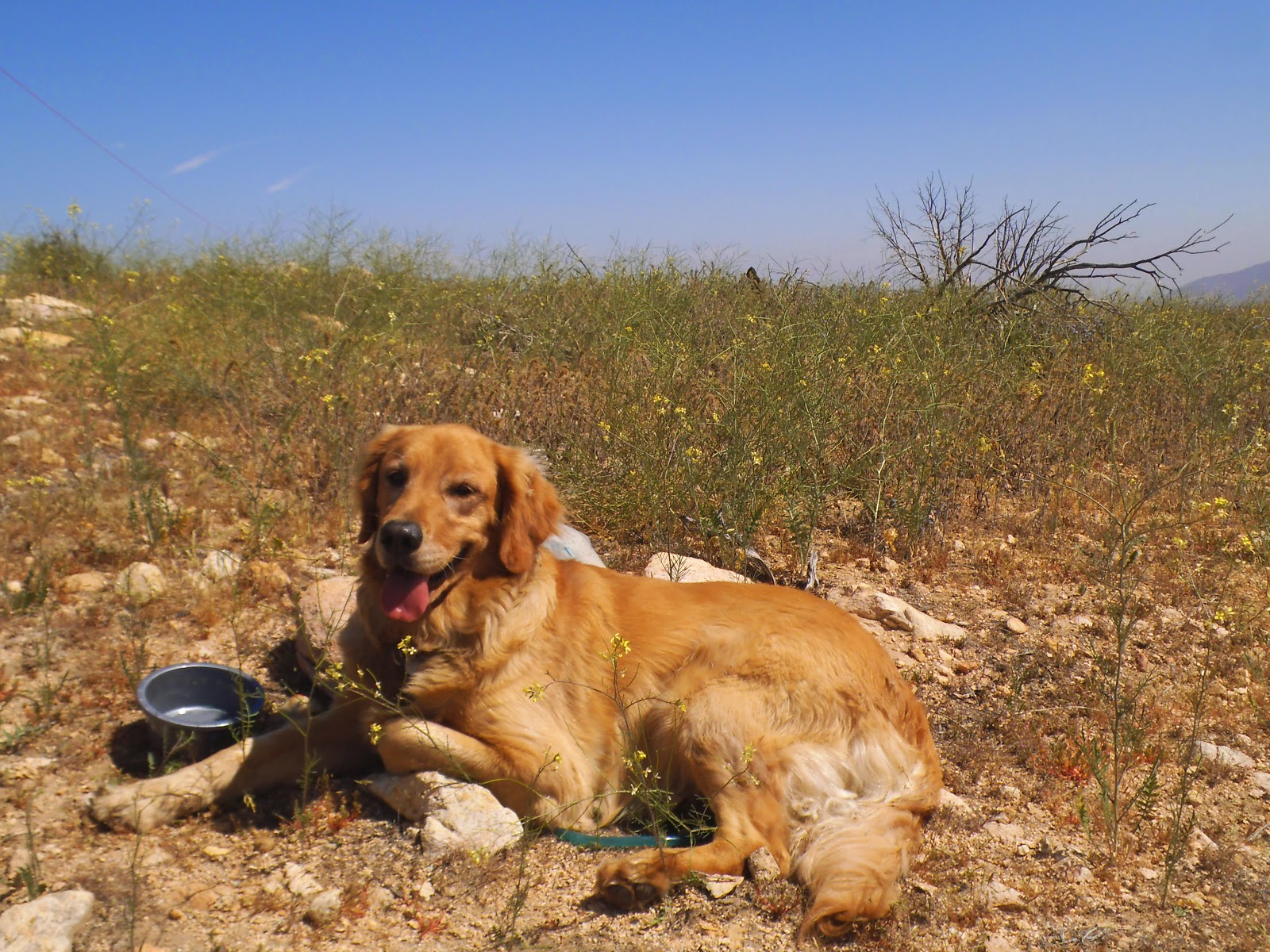
Roxy also enjoyed the wind break that the cement slab provided.


Roxy usually takes a break from her naps when I change antennas.  In the background, you can see the Jackite getting ready to fall over once again due to the wind.


I checked around the base of all the trees for the geocache, no luck.  The views were real nice today. I finally got the APRS SOTA spot to work.  I tried it several times as well as SMS with my phone and they both worked!  Thanks to Scott, WA9STI, and Bob, KB6CIO, for helping with my Kenwood D72a and getting me set up with the APRS/SOTA spots and the SMS.


The winds made for a nice clear day.  Although extremely windy, the temperature was perfect.  About 70 degrees hiking up and near 80 upon my return.

Another awesome SOTA adventure.  I will definitely activate this mountain again when there is no wind.  When I first went to 12m, 24.950, there was a station out of Italy calling CQ (I2JSB).  I could hear him quite well, but no luck with the contact.  Thank you to all chasers and spotters.  

2m - No Contacts

20m - N7KRN, W0MNA, NS7P, W0ERI, KF7JQU, WA9STI, KA5PVB, NE4TN, VA7ZOO, WD9F, AA5CK, WB5USB, W7CNL, K5FZH

40m - WA9STI, NA6MG, K6EL, KB7HH, N0OI, KB6CIO, WB0USI, KH2TJ, KJ6YKQ, N6JZT

12m - N4EX

Tuesday, April 22, 2014

Pt. 3788 W6/CT-167


Pt. 3788, CT-167, is on the northeast side of the Angeles National Forest.  You can get there via the 14 freeway or exit on Oro Vista from the 210 freeway as I did.  I enjoyed exiting at Oro Vista, getting a cup of coffee at Starbucks, and taking my time driving through the Angeles Forest watching the topography change. If you choose this route, stay focused on your driving as a lot of residents from the Antelope Valley drive through the mountains on their daily commute to Los Angeles.  It took me about 45 minutes to drive to the parking area on Aliso Canyon Road.  Pt. 3788 is located behind the rise in the center of the picture.  


Park in the large turnout on the the south side of the road.  The "road closed" barricade is a good marker to locate the parking.  Walk past the gate and climb this first hill.  There is no trail and it rises quickly.


Here is a view of the parking area from the first hill.  Although I have never had a problem in the Angeles, remember to lock your vehicle and do not leave any valuables in plain view.  Vehicles do occasionally get burglarized.  I was fortunate, as this is the first time I forgot to lock my door.  I remembered when I was on top of the mountain.


There is no formal trail.  Just follow the ridge line to the top.  It is steep in a few places.  It took me 57 minutes to get to the top and 31 minutes on the return.  I stopped a few times on the way up to take pictures and play with the GPS (and get a breather).


Roxy went on ahead and was waiting for me to catch up on one of the hilltops.


I am not sure what this is, but that horn on the head was weird.  It looked like some type of caterpillar.


Pt. 3788 is straight ahead.  I was a little concerned at this point, as the mountain looks bare.  I was trying to think how I would set up the "Jackite" and antenna.  I then remembered that Hal, N6JZT, mentioned in his blog that there is a post near the top.


This metal post appeared to be at the highest point on top of the peak.  The SOTA coordinates are a few feet south and slightly lower.


The wooden post was easy to find, as there is not much on top.  I was happy to have the post, as it was quite windy across  the peak when I arrived.  It may be a marker to indicate the forest boundaries, but there was no sign.  To me, it looked like it was put there for the sole purpose to assist SOTA activators to use as an anchor for the poles.


I slope my antenna from north to south.  This bush was nearly straight north of the wooden pole and I used it to tie off the antenna.


The clouds moved in while I was setting up and the temperature dropped.  I am glad I brought my fleece pullover, as I almost left it down below where it was much warmer.


No shade for Roxy to take her nap.


Parker Mtn., CT-153 is in the center of the photo. Several fires have burned through these mountains the last several years and there is not much vegetation on them.


The 14 freeway splits the center of the freeway, leading to the Antelope Valley.


There were poppies scattered around the mountain.


Here is another colorful caterpillar, this time without the horn.


Driving home, we saw this dead rattlesnake in the middle of the road. This is a reminder when out hiking to be aware of where you are stepping and sitting down for your activation.  These mountains have a lot of rattlesnakes and there are a few bites each year.

This was another awesome SOTA adventure.  Thank you to all chasers and spotters.  I made a Summit to Summit contact with Bob, KB6CIO, who was on W6/SC-362.

2m - no contacts

20m - WD9F, VE2JCW, W1MSW, NS7P, KB6CIO, WA9STI, WA2USA, W7PMF, KF7JQV

40m - K6EL, KB6CIO, WA6RIC, W7RV, NK6A, WA9STI, AE9F

12m - no contacts.  Called "CQ" for 20 minutes.    

Friday, April 18, 2014

Occidental Peak W/6CT-098


Today was a good day to activate Occidental Peak.  Heavy cloud cover and drizzle down below, clear skies up at the peak.  I tried to get here about six weeks ago, but work got in the way.  I parked across the street from the towers and began the hike.  It took me 37 minutes to get to the peak, including a few stops to to take pictures.  This is not a difficult hike, but be aware while on the trail as there are spots that have soft soil, lots of slippery leaves on the ground, and a small amount of rock hopping approaching the peak.


I parked across the street from the towers and began the hike up.


I stopped at Eaton Saddle on the way up Mt. Wilson road.  I had stopped to get a cup of coffee in the Crescenta Valley on the way up and it was drizzling.  I quickly returned home to pick up some rain gear for the hike.  I was driving in these clouds with the wipers on up to Clear Creek Junction when it opened up to sunshine.


Nice view of the towers at Mt. Wilson.  They looked like something you would see in a science fiction movie, reaching out to space.


After crossing a helipad, there is a nice view of Occidental Peak on the left and San Gabriel Peak, W6/CT-019, on the right.  The trail takes off on the left.


There was a pile of rocks at the summit.  Someone had removed the summit canister and it was nowhere to be found.  I spent about ten minutes looking all around the peak for the canister, no luck.


Not only had the summit canister been removed, but someone had shredded the register, tossing the  pieces of paper around on the peak.  What a coincidence that the one piece of shredded paper I looked at had fellow SOTA activator Bob, KB6CIO, written on it.


As I began to work the radio, Roxy settled in to a comfortable spot on the rocks for her nap.  20m was busy.  I had set an alert for 14.347.  However, the upper portion of the band had a lot of activity.  I moved down to 14.318 and fortunately NA6MG found me, putting out a spot.  After a while, I was getting stepped on and Bob, KB6CIO, recommended I move down to 14.317, where he spotted me.  I am always thankful to those that put up the spots.  Thanks guys.


Plenty of spots at the peak to set up the Jackite and run the antenna in a north to south slope.  It seems like this peak was made to activate as there is a four foot gap that runs north to south across the top.  


I really enjoyed being above the clouds and it was hard to believe that it was drizzling down below. Being above the clouds, felt like I was on top of the world.


Off in the distance past the mountain with the flat top is Mt Lukens, W6/CT-030.


Nice view on the way back.  The antenna on the left is where the trail begins.  The observatory is in the center of the photo.

Thanks again to all chasers and spotters.  It was a great day for an activation.

2m - K6QCB

20M - NA6MG, K7NEW, NM5S, KB6CIO, KC9TTR, W2USA, KS5Z, VE7CV, KF7JQV, NS7P, W7LTV, KD0VNQ,

12m - KB6CIO, WA3SEE, KC9TTR, N4EX, N0OI, KI4YZN, W6CHZ, AG6CJ, AE4FZ, NA6MG, K3JWG, KG3W, WA9STI, CO6RQ
  

Thursday, April 17, 2014

Flint Peak W6/CT-225


Flint Peak is another mountain in close proximity to my house.  It was an easy hike to the peak, which is not accessible, as there is a fence around several backup broadcasting towers.  To get to the trail head, I took Linda Vista from the 210 freeway, turned right on Lida and left on Figueroa. Take Figueroa until it ends at the trail head.  The trail is a good conditioned dirt road that eventually turns to pavement.  Leave the pavement and follow the hillside up to the fence line.  It took me about 15 minutes to get to the top.


There is a faint trail you can follow on the southeast side that will lead to the top.  The trail disappears as you get near the top, but just walk around the bushes until you reach the top.  Keep your eyes open for snakes when you traverse the mountain after leaving the road.


I connected my Jackite to the dead tree in the center of the picture.  There are plenty of places on the east side of the summit to anchor a Jackite or pole that are within the 80 vertical feet for an activation.  In the background are several trees outside the fence where you could hang your antenna if you don't bring a pole.  If you choose this area, watch your footing, as there is a lot of gravel, rocks, and loose soil that easily gives way.

      
As I normally do, I sloped my antenna in a north to south configuration.  This photo gives a better view of the tall trees in the background.


As I scouted the area to set up my equipment, Roxy wasted no time finding a shaded, grassy area to take her customary nap while I work the radio.


It was a hazy day that never cleared.  Off to the east above the water tank is Brookside Golf Course at the Rose Bowl.


On the south side of Flint Peak is Scholl Canyon Golf Course.  This is a fun 18 hole golf course and on clear days, there are views to the ocean.  It also has several tennis courts.  There is a gate outside of the entrance to Scholl Canyon Golf Course that prevents you from making access to Flint Peak from Glenoaks Bl.


The back nine on the course are quite challenging. If you don't hit the ball straight, it is going in the canyon.  The dump is in the background just past the golf course.


Here is a better view Scholl Canyon Landfill.


I was surprised to see that the gate was open on the south side leading into the compound.  The "No Trespassing" signs did not intimidate Roxy.


I recently purchased a GPS and have never used one before.  Yesterday, I received some excellent tutoring on how to use the GPS from a well skilled member of the Malibu/Lost Hills Sheriff's Search and Rescue Team.  This was an easy trek to practice with the GPS.  Due to playing with the GPS and the haze in the surrounding valleys, I did not take as many photos as usual.


Near the end of my activation, my son called and said that a swarm of bees had moved into our lemon tree this morning.  I thought he was exaggerating, until I got home and saw the bees. Hopefully they move on in a couple days.

Once again, I had a great time on another SOTA adventure.  Thank you to all chasers and those that spotted me.  I have been trying to learn how to use APRS on my Kenwood D72 HT so that I can self spot, but have not been successful spotting yet.

I made a total of 32 contacts today.

2m - N6JZT, KD6ZLV

20m - N6JZT, NS7P, NA6MG, K7NEW, W0MNA, W0ERI, W7QQ, KA5PVB, N4MJ, K7TQ, K5WI, ND0C,

40m - Zero contacts

12m - W0VX, W9BGX, KB9KEG, KC9ZOD, KO4SB, W5DXS, W3MTP, KI4MZS, KC9TEP, N5KLW, KF6YGY, NA6MG, KK4PGC, AA0PO, WN4N, KC9LHB, WX0Z, WB0ZQH

Thank you again to all chasers for the QSO's.

Mike - N6MKW