Saturday, May 31, 2014

Josephine Peak W6/CT-025


A view of Josephine Peak, W6/CT-025, while driving up Angeles Crest Highway.  A major fire, known as the "Station Fire", burned through the area in 2009.  Josephine Peak and the surrounding area has been closed since the fire to allow the new vegetation to grow.  The closure was lifted last weekend.


Parking is on Angeles Forest Highway at Angeles Crest Highway, the same as Pt. 4202, W6/CT-150.  It is a four mile hike on a dirt road with a nearly 1900 foot elevation gain.  Part of the trail had some shade in the morning, but was fully exposed on the trip home.  The four miles up took me 1:42 minutes, while the four mile trek down took about 1:20 minutes.


Here is the start of the dirt road on the north side of Angeles National Forest.  There is a gate blocking the road and the forest service forgot to take down the area closed signs.


After nearly 2.5 miles and a 1300 foot elevation gain, you arrive at Josephine Junction.  Turning right, as depicted in the photo, will take you to Strawberry Peak.  Turning left, behind me, will take you Josephine Peak.  It is just over 1.5 miles to the peak from the junction, with a gradual 600 foot elevation gain.


Roxy often gets ahead of me on the hikes.  She took a break in the shade waiting for me to catch up.


The road comes to an end and it is a short hike up a trail to the peak.


The benchmark was easy to find on a cement slab.  I had read there was a summit log, but I forgot to check for it.


I found the geocache on the summit.  The last log entry was 2009.  The canister was damaged, so I replaced it with a small tea canister and returned it to the hiding spot.


There was a fire tower on the peak many years ago.  The only thing that remains of the tower are the four posts.


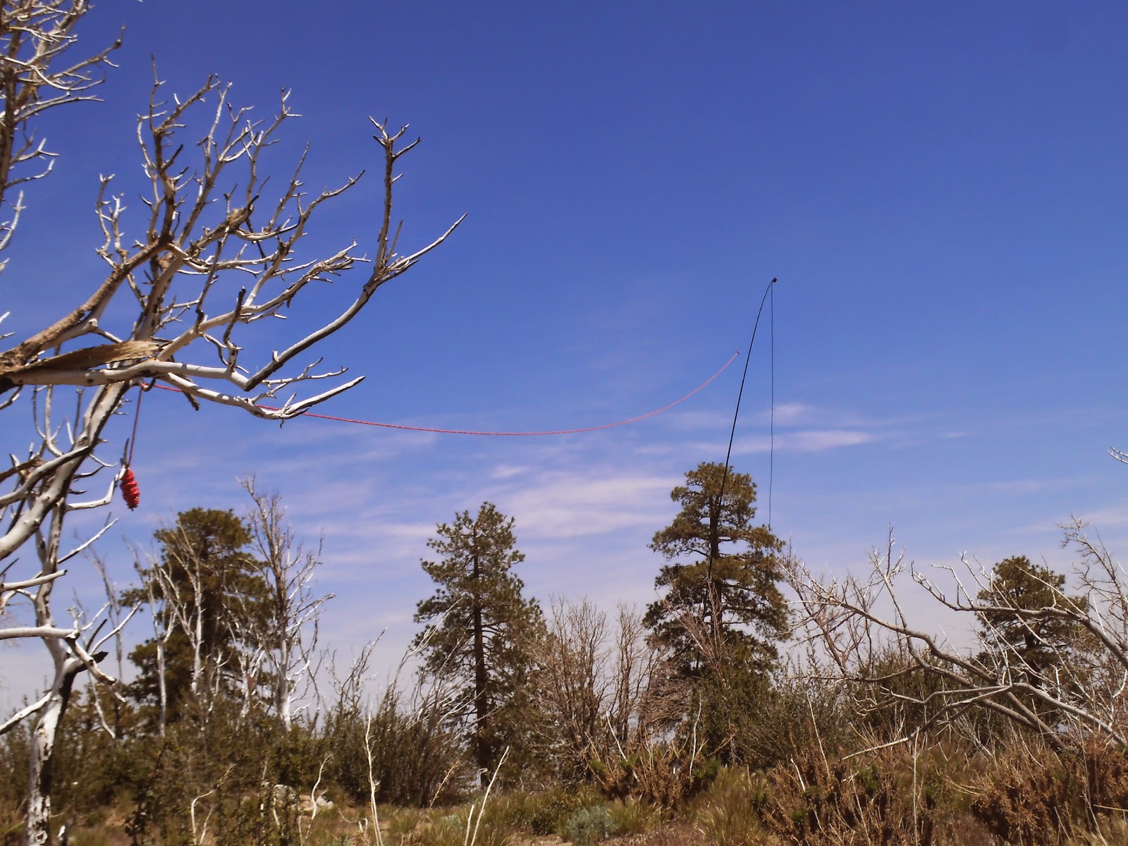
I anchored the Jackite to one of the tower posts. This was challenging, due to the weight of the Jackite and it fell over the first time I had it extended. Another option, depending on what type of pole you have, would be to place it in the rocks adjacent to the post.


I sloped the antenna over the side of the peak and tied it off to an old, burned tree.


Not sure what type of camera this is, maybe a weather cam, but it is directed towards Mt. Wilson.


There are several SOTA summits surround Josephine Peak.  To the left of the flag is Strawberry Peak (W6/CT-018) and to the right is Mt. Lawlor (W6/CT-089)


PT. 4202  W6/CT-150


Hoyt Mtn.  W6/CT-146


Mt. Lukens  W6/CT-030.  There are also views of San Gabriel Peak, Mt. Gleason, and Pacifico Mtn.


While activating, I heard a couple of voices behind and below me.  I looked down and saw two deputy sheriff's from Crescenta Valley Sheriff's Station.  I recognized one of them and shouted over to him.  Somewhat startled (they didn't see me on the peak), he replied, "Mike, what the hell are you doing up here?"  They hiked up and were quite interested in SOTA.  They were working the mountain car and are responsible for patrolling the Angeles National Forest.  Next time, I think I will hitch a ride with them.


Roxy found what little shade there was on the peak and settled in for a nap on the cool cement.  This may be her last hike for the summer as the road/trail is getting hot on her paws.

It was another awesome SOTA adventure.  Hal, N6JZT, contacted me on 2 meters from over 30 miles away and spotted me.  He also contacted and spotted on 20, 40 and 12 meters.  I had a lot of contacts from all over the country, including two from British Columbia.  12 meters was quite active with east coast stations.  Thank you to all chasers and spotters!

2m - N6JZT, KN6CCW, KK6HRS, KK6EHQ

20m - W0MNA, W0ERI, N0OI, NS7P, W7RV, W2USA, NE4TH, K6EL, AE9F, N6AKI, N6JZT, WR5U, N4MJ, KA5PVB, N7KRN, VA7VJ

40m - WA6RIC, N6AKI, W7RV, N6KZ

12m - N6AKI, N6JZT, N7UT. AF1T. N4EX, K6AA, N1EU, KB1RJD, VE7WJ, KB1RJC, W6HRH, W4JKC, W3DIY

Friday, May 23, 2014

Whitaker Peak W6/SC-076


Whitaker Peak is north of the Santa Clarita Valley.  A fire rolled through the area in 2007.  A lot of vegetation has grown back since the fire.  I wanted to activate this peak before the summer heat.  It is about 4.5 miles on a semi-paved road to a radio tower, followed by a nearly half mile of bushwhacking.  I decided to bring my bike and ride to the radio tower.  It was quite steep in a few sports, so I alternated biking and walking.  All said, I am glad I brought the bike.


I drove N/B on the 5 freeway, exiting Templin Hwy to the old Golden State Hwy.  After a few miles, there is a sign for Whitaker Peak.  There is plenty of parking at the turnout.    There is a locked gate that prevents driving the road.  At about the two mile mark, you will come to a fork in the road.  Take the left road and follow it to the radio tower 2.3 miles further.


The bike worked out well.  I hadn't been riding in at least five years, but had no problem.  I put a basket on the back which nicely held my pack.  I used a couple bungee cords to tie down the Jackite.  Behind the bike, you can see the gate that blocks the road.  The sign reads "Road Closed".


I rode to the radio tower and hiked nearly a half mile to the peak.  I thought I may be able to save some time and climb the peak from the north side, but the brush was extremely thick. As I rode along the west side towards the radio tower, I noticed that there was a 15-20 foot steep, almost cliff, to hike to Whitaker Peak.  Rather that try to climb the 15-20 foot cliff, I rode to the radio tower.  There is no trail to the peak.  Google Earth made it look like a fairly open area to hike.  There has been a lot of vegetation growth and it was a difficult hike.


I had read that there were three benchmarks on the peak.  I only found this one on the summit.  It was partially covered with dirt and gravel.


There was a nice spot on the peak to activate.  The flat rocks made for a nice spot to set up my equipment and a place to sit.  In the upper left of the photo is a pile of rocks that contain a summit log and in the upper right is the benchmark.  I brought a small thermos of coffee for this trek as it was a little cool in the morning and it sure was nice to have a cup of coffee on top of the peak.  I use an Yaesu 857d radio, 13.2v 10amp battery, three LNR End Fedz antennas (12, 20, 40), Kenwood TH-d72a HT, GPS, Summit Log, two pints of water.  Not pictured is my Jackite telescopic pole.  I have been happy with the performance of the Jackite, but I would like to investigate something lighter for the longer treks.


This pile of rocks on the peak contained a Summit Log provided by the Sierra Club.  No one had signed the log in about two years.  I initially thought it was geocache.


There were plenty of old, burned out manzanita trees that worked well for anchoring the Jackite.  There was a very slight breeze on the peak.


Here is the 12m antenna.  I sloped it south to north.


There is plenty of space on the peak to deploy any length of antenna.  


I found the geocache near the summit.  After checking the cache, I signed the log, returned the contents and returned it to its hiding spot.  The last log entry for the cache was October, 2011.


Here is a view of Townsend Peak, W6/SC-161, which I activated a couple weeks ago.


Piru Lake can be seen from the peak.  Castaic Lake can also be seen when looking east.


On the way back to the truck, I stopped at this rock and located another geocache.

 
This is the radio tower where I parked my bike.  There is also a geocache located near the tower.

It was a fun day on Whitaker Peak.  If you make this trek, be sure and bring plenty of water.  I worked 40, 20, 12 meters.  When I was on 12 meters, I had just made contact with KQ6P.  He spotted me and within a few minutes, I was bounced off the frequency by a DXer from Spain.  I also had some interference when I was finishing up on 40m.  This is the first time I have not taken Roxy with me, as I thought she would have difficulty keeping up with the bike. Thank you to all chasers!

40m - W7RV, N6KZ, NS7P, KB7HH, KC7DM, KB6CIO

20m - NA6MG, KA5PVB, KF7JQV, WA9STI, W7CNL

12m - KQ6P


Friday, May 16, 2014

Circle Mountain W6/CT-071


We have been experiencing a heat wave this week, so I thought I would drive over to the other side of the Angeles National Forest where it would be cooler.  Circle Mountain, W6/CT-071, is at 6900'.  From the 15 freeway, drive 1.3 miles west on the 138 and turn left on Lone Pine Canyon Road.  Follow Lone Pine for 7.7 miles to a turn out on the north side of the road and follow the road/trail behind the gate.  It is 1.25 miles of steep trail to the peak.


There is plenty of space to park without blocking the gate.  Circle Mountain is in the back of the picture.


The trail is easy to follow, but very steep.  There is a 900' elevation gain after you leave the fire road and begin the trail.  It was nice to have a few spots with shade for breaks.


We had to make a short detour around this tree that fell across the trail.


I stopped at a few Geocache sites along the way.  This one had not been logged in about 18 months.


I am not a big flower person, but it was nice to come across these bright colors in the trail.


The trail finally levels out somewhat and the peak comes into view.  This last section of trail to the top is very easy.


The summit is well marked with this pile of rocks.  There is also a summit log inside of a coffee can.  I signed the log and wrote a few words about my SOTA activation.  I had read that there were three benchmarks on the peak.  I couldn't find any of them.


This metal pole made a perfect anchor for my Jackite.  My last few activations had some moderate to heavy winds, so I wanted a strong support.  Fortunately no wind, just a light breeze to keep it cool.  The temperature was in the mid 70's.


I fully extended the Jackite and ran the antenna from north to south.  There is plenty of space on top of the mountain for any length of antenna.


 I have the 12m LNR End Fedz antenna, slopping to the south.  There were plenty of trees and vegetation in the area to set it up in any direction.


Displaying the SOTA flag.


I had a shaded spot to work the radio, but was soon pushed out by Roxy.


There are many trees near the peak to hang an antenna.  Next trip, I will leave the Jackite at home, reducing the weight in my pack.


With the recent heat wave we have experienced in Southern California, it was hard to believe that there was still some snow on the mountains.


A couple miles west of Circle Mountain is the town of Wrightwood.


It was a little hazy down below in the hot, Antelope Valley.


As I was breaking down my equipment and packing up, Roxy settled in for a final rest before the hike down the mountain.

Circle Mountain was a nice break from the heat.  For the most part, very good signals today.  I was on my last call on 12m ready to hang it up, when I heard KJ5FA with a summit to summit activation from W5A/CA-015, Bear Mountain, in Arkansas.  I even had a contact on 40m from W6FOG who was on a boat, I believe near Morro Bay.  Thank you to all chasers!

2m - KJ6VSI

20m - NS7P, K9ZMD, KB6CIO, WB5USB, N7KRN, KA5PVB, KF7JQV, K7KY, NE4TN, KC9TTR

40m - NA6MG, K6KZ, K7JFD, W7RV, KB6CIO, N6AKI, K6TUY, W6FOG, KB7HH, WA6RIC

12m - K2WCT, W1BFN, KJ5FA (S2S W5A/CA-015 - Arkansas)